Showing posts with label GOLD MINING IN AMERICA. Show all posts

Mining Project Marlin Gold Ltd.

by

Marlin Gold Ltd is a publicly traded gold and silver mining company with properties in Sinaloa, Mexico and Arizona, USA. Marlin priority is to promote its properties in the direction of commercial production and shareholder value through the growth of its wholly owned subsidiary, Sailfish Royalty Corp. La Trinidad property in Sinaloa, Mexico, commercial production declared on November 1 increase in 2014 

Mining project of Marlin

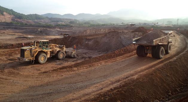
1. Mining Project La Trinidad

The wholly owned La Trinidad gold project consists of 61,612 hectares (within a larger land package of 118,518 contiguous hectares) in Sinaloa, Mexico. The project is located approximately 110 kilometers southeast of the city of Mazatlan and 42 kilometers southeast of the city of Rosario.  

The most advanced target on La Trinidad is the Taunus deposit, previously of Eldorado Gold Corp ( “Eldorado”) 1996-98. After completing a preliminary economic assessment, negotiating surface rights and receiving environmental permits, Marlin has completed construction and is in the process of restarting commercial production at the Taunus deposit with a fist gold pour on February 28, 2014.

The Taunus deposit is considered a gold-rich intermediate sulfidation state ephitermal system. The mineralization occurs in strongly silicified tectonic and Quartz matrix hydrothermal breccia. Marlin acquired the Taunus deposit in 2005 and previously unknown gold mineralization identified by the deposit to a depth of approximately 200 m below the surface.

Due to the breccias nature of the rock types in the deposit area, including the mineralized material, a drilling was initiated as a sonic drilling known the end of 2010, and continued until September 2011. This drilling style was used in order to achieve maximum core recovery

 2. Commonwealth Mining Project

The Commonwealth project is a development project in the historical district Pearce Mining is located in southeastern Arizona (Cochise County). Historically, the mined at the Commonwealth Mine deposits were high-grade silver and gold ores in quartz veins and stockwork zones held alongside the veins. 

Production began in 1895, with commercial scale mining of the high grade ores ending in the late 1920s. Small-scale mining from property owners during this period continued until 1942. The Commonwealth Mine produced approximately 12 million ounces of silver and 138,000 ounces of gold, to make Arizona’s second largest historic primary silver producer. 

The project was extensively explored and was drilled by a number of companies from the 1970s until the mid-1990s, the access to open lower grade natural resources were open pit and heap leach extraction. Work reached the pre-feasibility study level in 1996 before being stopped due to low gold and silver prices. This work included a technical report a historical non NI 43-101 compliant mineral resource estimate, the economic analysis and pit design. 

These studies included more than 15,000 meters of reverse circulation and diamond drilling, extensive metallurgical studies, geotechnical investigations and geological mapping, underground channel sampling, financial models and mining plans. No work was done until 2011 on the project from 1997, when the property was optioned by the previous owner and then exploration resumed again

The mineral deposits on the Commonwealth Project are typical silver dominant, low sulfidation epithermal veins and stockwork. The veins are best in a series of Cretaceous to Tertiary volcanic rocks of andesite composition developed correlative with the Mexican Lower Volcanic Series rhyolite. Cretaceous marine sediments of the Bisbee Group also host mineralization and are chemically favorable hosts. 

The two main arteries are the main vein and the North Vein. Between these two lane, a wedge of volcanic rocks is  well-developed quartz stockwork veins that is mineralized with silver and gold. The vein system has been mapped over 1 km strike length and further to the east under alluvial cover. 

Drilling of this strike length to a maximum depth tested at least 800 meters of just over 200 meters. There is considerable potential extensions of the known vein system both east, west and to find the angle of inclination. All known veins in the district have a combined length of about 4.5 km away. 

3. El Compas Mining Project

The El Compas property is located in the heart of the world’s most prolific silver mining area is located in Zacatecas, Mexico. El Compas is identified host to a number of gold-bearing veins on the surface. These veins were mined on the underground from a private Mexican company. Past production records are not available; However, Marlin has confirmed that high-grade gold and silver mineralization within at least two of the vein structures (El Compas vein and El Orito vein) exists. The results of the previous exploration work in a NI 43-101 resource estimate report compiled in January 30, 2011

Although exploration efforts to date have focused on the gold bearing vein system at surface, Marlin believes that there is significant potential to explore for large scale silver bearing targets at depth hosted within Mesozoic rocks that are typical of the district.

 4. San Albino Mining Project

The project Gold San Albino consists of 8,700 hectares (San Albino-Murra concession) within a larger contiguous land package of 13,771 hectares. San Albino is located about 173 kilometers north of Managua, the nation’s capital, and about 15 km southeast from the northern border of Nicaragua with Honduras. The deposit is hosted from a series of shallow dipping quartz sulfide veins of graphitic argillite. The San Albino resource model consists of three high-grade, vein systems – the San Albino project, Naranjo and Arras veins – over a strike length of 850 meters, a down dip extension of 925 meters, with a minimum true width of one meter and average true width of 2, 6 m. 


New Afton Mine

by

The New Afton copper-gold mine located about 350 kilometers northeast of Vancouver in the south-central interior of British Columbia. The New Afton mine 10km from the center of Kamloops is, which has a population of about 90,000 in southern central British Columbia, Canada,  and it is directly accessible from the Trans-Canada Highway.

The mine is owned 100% by New Gold Inc and property is only 10 kilometers from the regional hub of Kamloops and is easily accessible by paved road.  Kamloops acts as a hub for the mines in the region and is a popular destination for tourists and campers. 

The New Afton mine occupy the property the site of the historic Afton mine, a previous operation of Teck Resources Limited ( “Teck” ) and has an open pit mine, underground workings, historic support facilities, a new concentrator and recently constructed tailings facility.

The New Afton deposit of extending immediately below the Afton mine open pit in the southwest. New Afton gold mine began in June 2012, and production began in July 2012  ahead of schedule initial estimates. The timetable commercial production before underground operation is expected to produce an average of 85,000 ounces of gold and 75 million pounds of copper per year over a mine life of 12 years. 

The Company’s holdings in the area comprise the Afton Group and the Ajax Group. The New Afton deposit lies within the Afton Group. The Afton Group consists of 61 mineral claims included in a mining lease issued by the Ministry of Energy, Mines and Petroleum Resources on 29 November 2006 (the “Afton Mining Lease”). The total area of the Afton Mining Lease and all other claims is 12,450.4 hectares.

Geology And Mineralization New Afton Mine

The New Afton deposit part of a larger copper-gold porphyry includes circle within the productive the Quesnel Trough island-arc terrane,  host to many of the major copper and gold fields in British Columbia.  Pre-mineral rocks consist of intermediate volcanic rocks on the Triassic Nicola formation belong to mafic. Regional scale fault zones act as major controls at the batholithic rocks and associated in the area porphyry mineralization. 

The majority of deposit New Afton occurs as tabular, near vertical, southwest plunging body at least 1.4 kilometers along strike measurement of about 100 meters wide, a  with a down-plunge extent of over 1.5 kilometres. The deposit remains open to the west and at depth. 

Mineralization of copper sulphide veinlets and disseminations localized to brecciated margins between altered porphyry intrusions and Nicola volcanic rock is characterized. Copper occurs mainly as chalcopyrite and lesser bornite, with secondary chalcocite and native copper occurs in the upper nearer surface parts of the deposit. Gold occurs as sub-micron grains with copper sulfides

Since the start of commercial production in 1977, the New Afton mine has more than 800,000 ounces of gold and 850 million pounds of copper from both open pit and underground operation. 

Mineral Ore Processing In New Afton 


In New Afton, block caving, an innovative extraction process is used in excess produce from 11,000 tons per day. The block made cave is 600 meters below the surface and serviced by five main levels, extraction, undercut, apex, transport and ventilation. The final footprint of the cave will cover an area of ​​700 m in length from 100-150 in width.

Ore is specified rates are pulled over the footprint in advance in order to maintain an optimal cavity profile and limiting dilution to establish during its propagation. Approximately 202 drawbells the mine will be built to facilitate the removal of ore from the cave on the first phase of life.

A metro gyratory crusher, which opened in January of 2013, can mine ore tonnage can to maximize rates ore tonnage throughput rates. After the ore is crushed, it is then transferred into the underground conveyor system which transports the crushed ore 4.5 km to the surface.

On the surface, the ore is then processed by a prior art sulphide flotation concentrator. The most important key components are a SAG mill, a ball mill, pebble crusher, flotation cells and filter presses. 

The New Afton mill is designed to process 11,000 tpd (4 million tons per year) of ore at full capacity, for recovery copper, gold and silver. The mill will process a mixture of primary, transition and supergene ores using conventional crushing, grinding and concentration processes. Mineral separation will be flotation by gravity concentration and differential. A sharpening stage will be included in the flotation circuit. Life of mine recoveries anticipated to reach 88% copper, 87% gold and 75% silver.

Video New Gold In New Afton Mine, Kamloops,BC 
( Mining Methods )
 

Mesquite Mine

by

Mesquite Mine is a gold mining operations from New Gold,  located in Imperial County, California. The Mesquite gold mining operation acquired in June 2009 as a result of a successful business combination with Western Goldfields Inc ( “WGI).  Before the merger, WGI acquired the Mesquite Mine from Newmont Mining Corporation in 2003.  Feasibility study completed in 2006 and Commercial production in Mesquite mine started January 2008.

The Company became the owner of the Mesquite Mine in 2009 following the Western Goldfields Business Combination. The mine is operated by the Company’s wholly owned subsidiary, Western Mesquite Mines, Inc. (“WMMI”).

Currently, the major assets and facilities associated with the Mesquite Mine are:
  • Mineral resources and reserves in the Cholla, Big Chief, Rainbow, Vista and North Big Chief deposits.
  • The physical plant site including heap leach pads, process plant, workshops, warehouses, office buildings and drying equipment.
  • Facilities providing basic infrastructure to the mine, including electric power, heat, water treatment and supply, and sewage treatment.
  • Mine infrastructure including open pits, ramps, maintenance shops, and mobile equipment fleet.

Location Mesquite Mine

The Mesquite Mine is located in Imperial County, in Southern California, United States, 39 kilometers (24 miles) north of the Mexican border and 26 kilometers (16 miles) west of the border with the State of Arizona. Access to the property is a good quality roads. Local resources are in the cities of Brawley, California and Yuma, Arizona, at a distance from the mine of 56 kilometers (35 miles) and 84 kilometers (52 miles).

The mineral rights to the Mesquite mine a total area of ​​approximately 1,890 hectares (4,670 acres). They consist of 212 unpatented and 53 patented mining lode claims, 122 patented and 97 unpatented mill site claims, 266.3 hectares (658 acres) of California state leased land and 127.5 hectares (315 acres)  of fee lands.


History Of Mesquite Mine

Felizario Parra discovered gold in April 1876, worked placers until 1880, and sold out for $3000.00. Dry washing of low grade ores continued intermittently for 100 years, along with many exploratory shafts. From 1957 to 1980, Dick and Anna Singer mined, recorded earlier efforts, made studies, and sold their findings to Gold Fields Mining Corporation. After investing 70 million in exploration, development and construction, Gold Fields began full-scale production in March 1986.

The production reached 207,897 ounces of gold in 1992. It was expected that began this production rate would be maintained until 1999 when the mine would be exhausted.  Gold Fields and Santa Fe Pacific Gold Corporation, which has hired approximately 300 people contributed greatly to operate public and private needs and with full environmental problems until it was acquired by New Gold Inc. In 2001, the mine closed due a fall in gold prices, but it was reopened in 2007.


Geology & mineralization
The Mesquite district lies on the southwest flank of the Chocolate mountains in the upper plate of a regional scale shift. The host rocks are a fragment of Precambrian and Mesozoic continental crust with a very complex structure and metamorphic history, largely pre-dates the Oligocene age gold mineralization is mined today.  

The Mesquite Mine includes a number of gold deposits localized along two sub-parallel zones of northwesterly trending faults that. A sequence of gneiss host rocks imprints and locally invading granites much of the Mesquite district is covered by a veneer of unconsolidated post-mineral sand and gravel deposits that vary from several tens of meters in thickness. 

The gold mineralization at Mesquite has been deposited in an epithermal setting,  within 150 to 300 metres of the paleo-surface subsequent to amphibolite grade metamorphism. The bulk of the gold mineralization occurs as disseminations and along a northwesterly trending system of moderately steep developed venous faults and fractures dips.

Gold occurs primarily as native gold, ranging in size from very coarse disseminations submicron. Since the start of commercial production in 1985, the Mesquite Mine has more than 4 million ounces of gold. 

Exploration Potential

The Mesquite Mine achieved commercial production in 2008 with most of the exploration work carried out by New Gold’s predecessors. Since acquiring the Mine in 2009, the company has conducted a series of drilling campaigns to explore potential extensions to the known ore bodies and to upgrade resource classification to support future mine planning. New Gold continues to conduct periodic exploration and delineation drilling campaigns to support ongoing reserves development and mine planning.


Minerals Processing In Mesquite Mine
The Mesquite Mine is an open pit operation. Mining is carried out with a conventional truck / shovel open pit method. Run-of-mine ore is hauled directly to the leach pad for processing. Mineral ore processing is by heap leaching in a carbon-in column circuit test about 92% gold. Process recoveries are determined by oxidation. Ultimate Gold recovery for the mine reserves and life of mine production plan based on 75% recovery of oxide ores and gravel and 35% recovery of the non-oxide ores. Doré is from the site shipped a major refiner, where the gold and silver refined bullion. Gold is then sold to bullion banks on the spot market, outturned than at the refinery.

Cerro San Pedro Mine Mexico

by

Cerro San Pedro mine is a gold and silver mine located in central Mexico, around 20 km northeast of the capital San Luis Potosi, a city of which has approximately one million inhabitants with a strong industrial base. The mine is is easily accessed from the city center, and an international airport is not far away.

The Cerro San Pedro Mine is owned by New Gold through the Mexican Company, Minera San Xavier (“MSX”) with a stake of 100% and the first gold was poured in May 2007. This mine has a history about of ongoing legal challenges mainly due to a land use legality in area, and then the challenges were successfully overcome.

The Cerro San Pedro Mine has an enviable record of compliance with Mexican, about international environmental, safety standards, health and enjoys overwhelming local support as a trusted corporate citizen.

Mining History
Cerro San Pedro has been mined since the mid-1600s, production that have been generated on until the year 1940 around  2.5 million ounces of gold and 40 million ounces of silver. In 1592 padre Diego de la Magdalena with some of the peoples in Guachichil pueblo from Mesquitique.

Among them, a man named Cualiname or Gualiname, where they bring attention about  the golden outlines in their face paintings. The missionary asked him where he had obtained this pigment, and was told that in the east of Mesquitique much of the powder. 

Magdalena say to Francisco Franco approximately this discovery, and then notified to Captain Miguel Caldera , which is a of indigenous peoples for the Viceroyalty of New Spain and and that control of this region.

The latter named the locale San Pedro del Potosí, to honor his namesake saint and in memory of the famous mines of the Potosí in Alto Perú of the Viceroyalty of Peru, in present day Bolivia.

Several mining companies during the 1990s and the 2000s, has conducted mining operations in Cerro San Pedro before mining operations Metallica Resources and Peak Gold company merged to form New Gold in June 2008.

But now New Gold has already owns 100%  of shares and operates it through its wholly owned subsidiary in Mexico Minera San Xavier.

But in December 2009 Operations were suspended after a court order prohibited the use of explosives at the mine site. In  17 March 2010 the decision of the federal court about the restrictions imposed by the previous court order and doing a wisdom by giving back operations at the mine.

Geology & Mineralization In Cerro San Pedro mine

The mining district is located in the Eastern Sierra Madre fold-and-thrust belt of east-central Mexico. The district was originally discovered by Spanish explorers during the late 16th century.

The local stratigraphic section is dominated by Cretaceous limestones which have been intruded from the San Pedro porphyry, a late Cretaceous to early Tertiary age monzodiorite intrusive body emplaced along a regional scale thrust fault.

The mineralization occurs within an upper oxidized zone, disseminated gold and silver houses associated with iron oxides and a lower zone of gold-silver-zinc-lead sulphide mineralization.

Estimated the available historical records, among year 1575 and 1950 the Cerro San Pedro district produced approximately 2.5 million ounces of gold, for the production of silver by generating 40 million ounces of silver, while copper production generates around 93 million pounds  and other products 405 million pounds of zinc, 224 million pounds of lead

Nearly all of this production carbonate replacement mantos, veins, and fireplaces in the limestones next to Pedro porphyry San, which is host to disseminated and stockwork style mineralization.

recently has opencast the oxide zone in the production of approximately 1.6 million ounces of gold and 78 million ounces of silver from both limestone and porphyry ore types.

When combined with historical estimates of Cerro San Pedro is quarter estimated more than 4 million ounces of gold and have 100 million ounces of silver and associated zinc, lead and copper.


Processing Ore In Cerro San Pedro Mine

Mine operates as an open pit. Run-of-mine ore is processed by heap leaching and the Merrill-Crowe recovery process to recovery process gold and silver doré. Process plants consist of a heap leach pad lined which leading to a conventional Merrill Crowe recovery circuit for gold and silver .

Run-of-mine ore is stacked on the leach pad and then a pregnant solution flows toward the bottom through the heap leaching of gold ore, which is then solution from result this mineral ore pumped to the Merrill Crowe plant for stages of the process produce gold-silver doré.

Then the results of doré is transported from location to a refinery, where the silver and gold to be refined to make gold bullion. Gold is then sold to bullion banks on the spot market

Video New Gold Inc Cerro San Pedro Mine Mexico

Blackwater Mining Project New Gold Inc

by

Blackwater mining project constitute a mining project of New Gold, and located on the northern flanks of Mount Davidson in Nechako Plateau, approximately 160 kilometers southwest of the city of Prince George, 110 kilometers southwest of the town of Vanderhoof in central British Colombia. The project is located approximately 450 kilometers north of New Gold’s New Afton project. 

New Gold Inc mining project of this currently in the environmental assessment phase comprises 75 mineral tenures totaling 305.78 square kilometers, and has a total area of property 227 mineral claims covering an area of ​​1,046.78 square kilometers. The project is appealing and close to infrastructure, the terrain is characterized by rolling hills, the project is accessible by road and access to low cost hydro power is with the construction of a 230 kV transmission line. 

History Of Gold Projects  Blackwater

The Blackwater Project area has been actively explored since in 1973 by Granges Inc from streams draining the Mt.Davidson area with the discovery of anomalous concentrations of silver, lead, and zinc in silt samples taken. History of the workmanship of the project includes soil geochemistry, geophysics and reverse circulation and diamond drilling.

Richfield’s work on the Blackwater Gold Project began in 2009 when the company recognized the bulk gold potential on the property. In March 2009 Richfield optioned the Davidson and Dave claims from Silver Quest Resources Ltd. and the Rozek family respectively.

The initial mineral resource estimate for its Blackwater project was published in March 2011 and was on 25,263 meters of drilling in 77 holes on the area. An updated mineral resource estimate was prepared in September 2011 and has an additional 71 holes (24,660 meters) March estimate, bringing the total number of core drilling up to 148 (49 223 meters). 

Released indicated  and Inferred mineral resource estimate in March 7, 2012 presents drill results to December 2011. It is estimated an indicated resource of 5.5 million ounces of gold and an inferred resource of 2.3 million ounces of gold 0.4 grams per tonne cut - off grade 

Mining projects Blackwater reported mineral resource in March 31, 2013 within a conceptual pit shell at gold equivalent cut-off values ​​reported 0.3-0.4 grams per tonne. The deposit contains measured and indicated mineral resources for the direct processing of 306 million tonnes at 0.88 grams per tonne gold and 5.8 grams of silver per ton, which representing 8.6 million ounces of gold and 57.5 million ounces of silver. 

Moreover, the measured and indicated mineral resources suitable for storage and the future of the mine processing contains 91 million tonnes with 0.30 grams per tonne gold and 4.3 grams of silver per ton, which representing 0.9 million ounces of gold and 12.6 million ounces of silver.

Conforms to the CIM (as defined at the ending of the publication) this mineral resource estimate is compliant with definition standards required pursuant to National Instrument 43-101 and is based on a geological block model that contains 286,966 individual assays from 309,516 meters of core of 1,003 drill wells at a nominal distance of 25 meters to 50 meters.

 Assay data density is sufficient to classify the mineral resource when the measured and indicated confidence levels as necessary to support the estimation of a mineral reserve. The drill Gap database was supported by approximately 80,000 quality assurance / quality control (QA / QC) check sample supports assays. 


 Geology & Mineralization In Blackwater project

The Blackwater project within the Stikine Terrane of Inter Montane Belt of central British Columbia. The Stikine Terrane includes Jurassic to Early Tertiary magmatic arc and the associated sedimentary rocks. The Blackwater deposit hosted by a sequence of intermediate and felsic volcanics belonging to the Late Cretaceous Kasalka Group. These rocks overlain by Eocene age post-mineral volcanics belonging to the Ootsa Lake Group and backed by basinal clastic rocks of the Late Jurassic Bowser Lake Group

A well-developed system of northeasterly, northwesterly and northerly striking faults cutting the whole package and acts as the main control to gold-silver mineralization in the region. Quaternary glacial, colluvial and alluvial obscure most of the bedrock in the immediate project area.

gold and silver mineralization at Blackwater occurs obtrusive within an intermediate sulphidation, epithermal gold-silver system that takes place within two kilometers of a cluster of mineralized porphyry centers the same Late Cretaceous stratigraphic Kasalka group.

Host rocks within the deposit are pervasively hydrofractured, pyritized and changed to a mixture of silica and sericite. The mineralization is typified by gold-bearing polymetallic sulfides (pyrite, sphalerite, marcasite, pyrrhotite) as disseminations and porosity infillings in the fragmentary unit of the deposit.

Mineralization is strongly controlled by the northwest and northeast extending zones of of shearing and tectonic brecciation. The deposit is bounded by post-mineral trench forming fault in the north and south. A major north-south trending fault transects the orebody, it is divided into two distinct geological domains integral part of the mineral resource block model.

The feasibility study for the project in 2014, New Gold identified several areas of potential gold mineralization over 1,100 square kilometer property package. New Gold is currently leading his focus for more gold and silver resources in several kilometers of the known epithermal mineralization at Blackwater and the recently discovered porphyry copper-molybdenum mineralization in the south.

Video Blackwater Project New Gold Inc 


Rainy River Gold Project New Gold Inc

by

The Rainy River project constitute gold mining project which is located in Richardson Township, Approximately 65 kilometers northwest of Fort Frances in northwestern Ontario. This mine project managed and owned by New Gold Inc which is the intermediate gold producer.

The property is centered in the Richardson Township at northwestern Ontario, approximately 160 kilometers south of Kenora and 420 kilometers west of Thunder Bay. The property has exceptional infrastructure with access road, electrical wires, and railway 21 kilometers south of the property. 

The project estimated to be productive a 21,000 tonnes per day processing of a combination of open pit, underground and stockpiled ore. The project is expected to produce 325,000 ounces of gold per year to below the industry average cost. New Gold intends to pursue the possibility of higher grade ounces to the project early years, and increasing processing lower grades from the processing of storage at the finish of the mine life , with the goal of cash flow and  to improve profitability of the mining project. 

Exploration on Rainy River Gold Project began in 1967 with Noranda, International Nickel Corporation of Canada, Hudson Bay Exploration after that by  Development and Mingold resources until operating in 1989.  The Ontario Geological Operating survey geological mapping in 1971 and again in 1987 to 1988 in connection with a rotasonic overburden drilling program. 

Nuinsco began to conduct exploration activities on location between 1990 and 2004. In June 2005, Rainy River to Ream acquired a 100% interest in the project from Nuinsco. Nuinsco drilled from 1994 to 1998 to a series of widely spaced reverse circulation (RC) drill holes fifteen kilometers far, Nuinsco a series of diamond drill program completed to assess the mineral potential of the anomalies that led to the original discovery of the 17 zone in 1994

After acquisition in 2005 Rainy River Resources key sections relogged the historic core on the property drilled, and then enter all the data into a GIS database.

Geology And Mineralization In Rainy River project

Rainy River project consists of several multiple volcanogenic-style gold deposits situated within the Late Archean Wabigoon Subprovince of Ontario. Local stratigraphy comprises a series of tholeiitic mafic volcanic rocks structurally overlain by calc-alkalic dacitic metavolcanic rocks that host the bulk of gold mineralization in the district.

Mineralized zones generally follow the regional northwesterly strike and southerly dip of stratigraphy. The largest of these, the ODM / 17 Zone extends 1,600 meters along strike, 975 meters down dip (open at depth), and has a true width of 200 meters.

Three main types of gold mineralization have been auriferous sulfide ¬ ± quartz stringers and veins in felsic quartz phyric rocks (ODM / 17, Beaver Pond, 433 and HS zones), quartz-ankerite-pyrite shear veins in mafic volcanics (CAP /: Rainy River identified South zone) and sulfide-containing silver-enriched quartz veinlets in dacitic tuffs and breccias (Intrepid zone).

Identified most of the gold mineralization to date in the sulphide occurs stringers and veins within the felsic quartz bearing rock phyric. In a fourth type of mineralization of copper-nickel-platinum minerals occurs a little, young mafic-ultramafic intrusion (34 Zone) within the main cluster of gold and silver deposits located. All deposits Demonstrate a certain degree of deformation, with the exception of copper-nickel-platinum-bearing type.

Exploration Potential Rainy River

The Rainy River project represents one of Canada’s newest emerging gold districts. The Rainy River was explored for the first time for nickel sulphide mineralization in the mid-1960s. The final recognition of district gold potential in 1988 and led to the discovery of gold mineralization of stratiform auriferous volcanogenic style sulphide deposits.

So far, exploration efforts have been delineated become 3.8 million ounces of gold reserves is plus additional 2.7 million ounces of measured and indicated resources. As the project advances toward its mid-2017 target for the start of commercial production, New Gold continues to focus on the discovery of additional gold resources with the potential to enhance and extend the commercial life of the project.

Video Rainy River Gold Project New Gold Inc

Gold Mining In The Carolina Slate Belt

by

The Carolina Slate Belt is a gold-wealthy strip from Virginia, south through North and south Carolina and ends up in Georgia. Numerous rivers and streams in this area  contain placer gold deposits. Although most people in the US knew of the gold  as a result of the gold rush California, the first gold discovery in the United States in North Carolina was within the Carolina Slate Belt. Gold was first discovered in the United States in 1799 in the Little Meadow Creek in Cabarrus County, North Carolina. 

Although this discovery was not as much attention as the discovery California , In fact most of the experienced gold miners who moved to California, during the California Gold Rush had honed their skills mining areas along the Carolina slate belt. After the first gold find some other discoveries in shale and thus more gold mines were developed. 

Geology In Carolina Slate Belt 

The Carolina Slate Belt majorly composed and derived from rocks that were deposited from volcanic eruption on the surface of the Soil and then sedimentation. The slate is thus characterized by low grade metamorphism that a Large number of rocks is a slaty cleavage here.

Inside Piedmont for the most part consists  and often occur from metamorphic intrusive rocks such as various types of gneiss. The whole region Piedmont is underlain at a depth of Approximately 20 km from a region, the seismic waves reflected emphatically.

This area is often regarded as a series of faults along the upper part, including the uncovered portion of Piedmont, moved westward over a number of completely unknown rocks. The error may twist upward toward the west and rise to the top as one of the various thrusts in the Appalachian Mountains.

The slate is made up of low grade metamorphosed volcanic and slate cleavages. The mountainous Piedmont of North Carolina isolates the Triassic-Jurassic rift basin and the level Coastal Plain from the hilly Blue Ridge and Appalachians. 

The coastal plain consists of Mesozoic-Cenozoic sediments created when the North Atlantic got to be wider and the Triassic-Jurassic rift basins of sedimentary rocks in the plan during the opening of the Atlantic Ocean formed. The Raleigh Belt and Eastern slate belt containing rocks Love that of Piedmont. However, these are only exposed to the east of the Triassic-Jurassic basins and their connection to the Piedmont is not entirely clear.  

The Piedmont can be divided into two parts, the western and eastern areas of both the two very different rock suites. The eastern part is the Carolina Slate Belt, while the western part is often referred to as the interior of Piedmont.  A number of geologists often combine the Carolina Slate Belt and Inner Piedmont, what is commonly known as the Carolina Terrane 

Two of the most important gold mines in the Carolina Slate Belt included :

Haile gold mine
 
The mine developed from a gold deposit, which was discovered in 1827 on the farm owned by Benjamin Haile in Eastern Lancaster County near Kershaw, South Carolina. The mined operated until the early 20th century operated when the gold deposits originated. This mine was one of the most productive gold mines during the years. 

The Dorn Mine

This is another Large mine in the Carolina Slate Belt. The mine is located in McCormick County, South Carolina. Gold in the mine was first discovered by William soon began Burkhakter Dorn in 1952. The mining at the mine after Dorn and lasted more than 120 years. The slate has several other mines quite a significant amount of gold. In fact, most major gold mines in North and South Carolina Located on the Slate. 

There are numerous other smaller placer mining are found throughout Virginia, North Carolina, South Carolina, and Georgia. All of the gold-bearing areas most rich within these states are found in the slate belt.

Mining has been done in this area for over 200 years, but there are still Nice amounts of gold in the streams and rivers in the Carolina Slate Belt are found.

Read Also

El Limon Mine In Nicaragua

by

The Limon mine constitute mine which located in northwestern Nicaragua Approximately 100 kilometers northwest of Managua, capital of Nicaragua. The property is easily accessed by paved highway and 15 km gravel pit road with a total road distance of 140 kilometers from Managua. The property extends along the border of the municipalities Larreynaga and Telica the Department of Leon and the municipalities of Chinandega and Villanueva of the department of Chinandega. 

The Limon Mine consists of 12,000 hectares of “Mina El Limon” mineral concession, issued for a period of 25 years and expiring in April 2027. Each mineral properties under the Nicaraguan mining law subject to an agreement by the Government of Nicaragua, which include the rights to develop,  to explore, for mine, extract, export and sale found mineral resources and made the concession. 

The el Limon mine are obliged to submit annual reports on its activities and production statistics to government . Escalating annual surface taxes are payable to the Nicaraguan government for the Mina El Limon mineral properties.

The surface tax  was US $ 4.00 per hectare in 2009 and a maximum  of US $ 12.00 per hectare in 2012 has been reached and will be maintained through the years that followed. 

B2Gold Company hold an indirect 95% interest in Triton Minera SA ( “Triton”), which owns and operates the Limon Mine, and holds three other mineral concessions, all at an exploration stage. The remaining 5% of Triton held  by IMISA. Triton holds directly or controls the surface rights for all of the property on which the current mining, milling, tailings and related facilities are located at the Limon Mine. 

Triton also owns a part of the surface rights to the properties. As required, Triton has negotiated and access agreements with individual surface rights holders in respect of these properties entered for which it does not hold the surface rights within the concession. All of the permits required for exploration, mining and milling activities are in place for the Limon Mine.

RG Exchangeco Inc., a subsidiary of Royal Gold, Inc., holds a 3% NSR royalty on the gold production  from the Limon Mine and certain other concessions.

The revenue from the Limon Mine is also subject to a 3% VAT payable on the production of gold to the Government of Nicaragua,  which is considered a deductible expense for purposes of computing corporate income tax.

Internacional de Comercial SA holds a license fee of 5% of net profit of Triton Mining (USA) LLC ( “Triton USA”) equal, indirect subsidiary, a holds 47.5% interest in the Limon Mine. The net profit from the difference between gross income defined on spending (all revenue from the operation of Triton USA their business is obtained) (where indicated as costs and as costs of Triton USA from its operations result, including working capital and operating costs, pay royalties, borrowing costs, taxes and Common selling and administrative expenses). 

Mineralization At The Limon Mine Nicaragua

The gold mineralization at the Limon Mine and northwestern Nicaragua is typical of low-sulphidation, quartz-adularia, epithermal systems. These deposits were formed in relatively shallow, typically from just below the surface to a little more than a kilometer deep.

To date, this is the only type of gold mineralization was found and reported in the tertiary rocks in northwestern Nicaragua. Silver is usually a commercially minor by-product of gold mineralization.

All gold production was hosted by quartz vein and quartz vein breccia deposits in the linear structural features and often accompanied minor pyrite and trace amounts of base metal sulphides.

Gold is dispersed generally to very fine-grained and relatively evenly across the higher grade portions of the veins. Only low incidence of disseminated or floor type epithermal precious metal mineralization reported. , Mineral deposits or deposits of other metals in the area not known

Three producing and past-producing vein systems do nearly all the gold from the Limon Mine District produced; these are the Limon, Santa Pancha and Talavera systems. A Large number of other weakly mineralized quartz veins have been identified and explored, some with smaller development and production

The productive vein systems are approximately 1.0 to 2.0 kilometers Far with vein widths of less than 1.0 meters to 25 meters. All economic gold mineralization to date is located within 400 meters of the surface.

The productive and prospective surveys within the vein systems vary systematically in the district. Post-mineral disturb error locally and the veins balanced.

Geology In Limon Mine

The Limón mine is located on the eastern edge of the Nicaragua graben in an area of low hills, which are predominantly underlain by Miocene-Pliocene volcanic layers to felsic by minor intermediate cut intrusive bodies.

Gold mineralization in the district is classified Limón with quartz-adularia vein systems as low sulphidation epithermal deposits. These deposits were formed in relatively shallow, usually below the surface a little more than a kilometer deep, from neutral pH hydrothermal fluids with temperatures C <150o C to 300o. The volcano-putonic arc of western Nicaragua a common tectonic setting of these deposits. 

Exploration El Limon Mine In  2015

The drilling 2015 has continued near term mine development in Santa Pancha and upgraded to perform the U -Bahn resource category, which specifically SP1 (# 8 waveband). Greenfields exploration is for testing ongoing potential of the current mining areas, some of which will be drill tested towards the end of 2015.

Past Exploration

Focus of the exploration work on the Limon property to date on the Santa Pancha 2 cores (Pozo # 4 and # 5) area, the current underground 1 km north was drilling located in Santa Pancha. 1 the hanging wall structure in Santa Pancha 2 appears the best host of the mineralization to be where the average widths were intersected between 2 to 15 meters.

Drilling in 2014 on the Santa Pancha 1 vein system helped establish continuity in an area that is planned to be mined in 2015. Results of significance LIM 14-3884,for  the 73.34 g / t gold over 2, 5 m true width and LIM 14-3883 with 26.6 g / t gold over 1.7 m returned true width.

Results significance further north on the vein structure of Santa Pancha 2 comprise LIM-14-3857 with 7.9 g / t gold over 3.95 m true width and LIM 14-3854, the 5.2 g / t gold over 5.3 meters true width back.

In Fair east of vein Veta Nueva returned encouraging results from drill Gap 14-3876 LIM, the 8.6 g / t returned at the structure Atravesada gold over 2.7 meters, which working drilling in 2014. Atravesada further drill tested in 2015 to search within this vein structure in grade continuity.

Mining And Ore Processing El Limon Mine In Nicaragua


The vein system in Santa Pancha has become the primary is provided source for the underground exploitation of ore. The access for underground mining in Santa Pancha by ramp system that branches at the 90 meter level, both in North and Central ramps.

The deepest level of the mine is Approximately 170 feet below the surface. Two increases support the mine ventilation system and one of them serves as an emergency escape route. Future mining in Santa Pancha requires the mine to deepen and extend the mine along strike.

Dewatering is a critical component of mining in Santa Pancha and pumps are working in two existing wells that water levels to ensure are kept at a safe level below the lowest working. Continued deep development in Santa Pancha and improvements in this drainage system are a significant part of the capital estimate for the next year.

The Limon Mine Mill is a 1,000 tpd (  tonnes per day ) CIP gold recovery plant. The mill throughput capacity increased to 1,0 tons per day in 2013 made due to the ongoing improvements in the mill, and is currently in a throughput capacity of 1,375 tonnes per day.

Run of mine ore is hauled by truck of Little open pits and Santa Pancha Mine (six kilometers from the process plant) (in a radius of between one and five kilometers are of the process plant).

Ore is stockpiled in front of the primary crusher or ore is thrown in front of the primary crusher to the stockpile or directly in the 36-ton capacity dump hopper feeding the crusher. This stock is used to mix the various ore sources to maintain a consistent grade in the mill feed.

Video Under Ground Mine In El Limon Nicaragua


Read Also 

- Libertad Gold Mine Nicaragua
- Mining Operation Otjikoto By B2Gold Corp

Top Ad 728x90