Showing posts with label GOLD MINING. Show all posts

Peak Gold Mines

by

Peak Gold Mines is a gold and copper mine underground which located in the Cobar Gold Field of Central West New South Wales, Australia, and began production in 1992. Peak Gold Mines produces gold dore for sale at the Perth mint and copper concentrate is sold to markets in Asia. 

The Peak Gold Mines comprise five commercially operating mines and a copper-gold-processing plant. The deposits, which all currently mined from underground, include, from south to north, the Perseverance, Peak, New Occidental, Chesney and New Cobar.

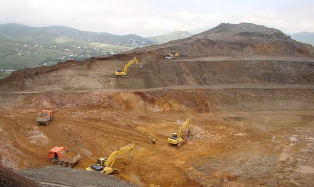
The Peak, New Occidental and Perseverance ore body are is accessed via a shaft and surface reduction in peak site. The new Cobar and Chesney ore body are accessed via a decline near the base of the new Cobar open pit. The Peak site is the processing plant and administration building.

At peak, Perseverance, New Occidental and New Cobar, do mining by using a bench stoping. If Chesney, a combination of bench stoping and open stoping is planned mining proceeds from bottom to top in each panel. Drifts are driven along strike to the ore at any level, developed a slot and ore is blasted into the cavity. Ore is extracted and waste rock is used to backfill the void. 

Peak Gold Mines in Cobar mining area, located about 600 kilometers northwest of Sydney and eight kilometers south of the town of Cobar in New South Wales (NSW), Australia. The property is of Sydney over 700 kilometers of highway and eight and a half kilometers of secondary and private roads. Limited resources are available at Cobar and generally available in Dubbo 300 kilometers east. The mines are operated by Peak Gold Mines Pty Ltd ( “PGM”), a subsidiary of the Company

Gold Mines Mineral rights exist about 86 110 hectares of mining leases and exploration licenses, including 33 832 hectares subject with an average maximum temperature of 33 degrees Celsius in summer and 16 degrees Celsius in winter.

Gold Mines Mineral rights exist about 86 110 hectares of mining leases and exploration licenses, including 33 832 hectares subject with an average maximum temperature of 33 degrees Celsius in summer and 16 degrees Celsius in winter.

Goldmines’ climate is semi-arid and average rainfall is about 416 millimeters per year. The landscape is mostly flat, consisting of sandy plains with small waves. The mine is named after the “peak”, a small conical hill 324.3 meters above sea level, which has the peak deposit located on its southern base. The vegetation at the mine consists largely of semiarid low forest, with little seasonal creeks and  rivers lined by taller eucalypt species.

Geology & Mineralization In Peak Gold Mine

The Cobar mining area is along the eastern margin of the Early Devonian age Cobar Basin, which lies in the northern part of the central belt of the Lachlan Orogen, and will of the regional scale Rookery Fault system.

The Peak Gold Mines operation is located in a 10-kilometer section of Rookery fault system, referred to as the “Peak mine corridor.” until today, five separate gold-copper deposits were developed in underground mines. Listed from south to north, they include: Perseverance, Peak, New Occidental, Chesney and New Cobar.

A sixth deposit, Great Cobar which was mined from around the time of the first world war until the mid-1940s, is located at the northern end of the peak-floor and provides an area of ​​renewed exploration focus.

Individual deposits occur as steeply dipping veins with equally short strike lengths (less than 300 meters), narrow widths (10 to 30 meters) and long vertical dimensions. For example, the peak and Perseverance have defined deposits to vertical depths of 500 to 700 meters. The Chesney and New Cobar deposits are currently being defined by shorter vertical areas and like all of the deposits along the Peak mine corridor remain open at depth. 

Mineralization of polymetallic sulphides consisting of gold-copper vary -lead-zinc assemblages at peak and Perseverance to simpler copper-gold in New Cobar, Chesney and Great Cobar. Generally, gold mineralization occurs as discrete lenses within broader envelopes of base metal mineralization.

Including commercial mine production from Great Cobar and the resurgence of mining in 1991, the Peak Mines corridor produced over 3.7 million ounces of potential gold and 200 million pounds of copper.

Processing Of Mineral Ores

Ore from Peak, Perseverance and New Occidental underground is crushed and hoisted onto a surface stockpile and eventually into the mill feed conveyor SAG. Ore from New Cobar and Chesney is dragged tip, where it is fed to the SAG mill feed conveyor via a separate container.

Gold and silver are recovered in a gravity circuit with Knelson concentrators, further concentrated in an intensive leach reactor electrolytically and mud in a gas-fired furnace smelted to gold doré bars produce. Gold, silver and copper are obtained as copper concentrate in a conventional flotation circuit.

The flotation concentrate is thickened, dewatered and stockpiled prior to the stage of the process to transporting to the smelter. A third method of gold and silver recovery by cyanidation in a tank leach circuit. The resulting sludge is smelted into gold dore bars. Metal recoveries are approximately 90% and 87% for gold and copper.

Exploration Potential In Peak Gold

Since the beginning of commercial production in 1991, underground exploration to the known ore body along the Peak corridor added to new reserves again, its for replace annual production.

For example, with a mineral reserve of 936,000 ounces of gold in the Peak deposit in 1991 begin to sustainable exploration and development mining reserves substitute has  of the end in the delineation of mineral reserves and resources amounting to almost three times  that amount as of the end of 2014.

With a twenty-year track record of successful reserves replacement and control of more than  75 kilometres of prospective geology along the greater Rookery fault trend, exploration at Peak continues to offer significant upside toward future exploration success.

New Afton Mine

by

The New Afton copper-gold mine located about 350 kilometers northeast of Vancouver in the south-central interior of British Columbia. The New Afton mine 10km from the center of Kamloops is, which has a population of about 90,000 in southern central British Columbia, Canada,  and it is directly accessible from the Trans-Canada Highway.

The mine is owned 100% by New Gold Inc and property is only 10 kilometers from the regional hub of Kamloops and is easily accessible by paved road.  Kamloops acts as a hub for the mines in the region and is a popular destination for tourists and campers. 

The New Afton mine occupy the property the site of the historic Afton mine, a previous operation of Teck Resources Limited ( “Teck” ) and has an open pit mine, underground workings, historic support facilities, a new concentrator and recently constructed tailings facility.

The New Afton deposit of extending immediately below the Afton mine open pit in the southwest. New Afton gold mine began in June 2012, and production began in July 2012  ahead of schedule initial estimates. The timetable commercial production before underground operation is expected to produce an average of 85,000 ounces of gold and 75 million pounds of copper per year over a mine life of 12 years. 

The Company’s holdings in the area comprise the Afton Group and the Ajax Group. The New Afton deposit lies within the Afton Group. The Afton Group consists of 61 mineral claims included in a mining lease issued by the Ministry of Energy, Mines and Petroleum Resources on 29 November 2006 (the “Afton Mining Lease”). The total area of the Afton Mining Lease and all other claims is 12,450.4 hectares.

Geology And Mineralization New Afton Mine

The New Afton deposit part of a larger copper-gold porphyry includes circle within the productive the Quesnel Trough island-arc terrane,  host to many of the major copper and gold fields in British Columbia.  Pre-mineral rocks consist of intermediate volcanic rocks on the Triassic Nicola formation belong to mafic. Regional scale fault zones act as major controls at the batholithic rocks and associated in the area porphyry mineralization. 

The majority of deposit New Afton occurs as tabular, near vertical, southwest plunging body at least 1.4 kilometers along strike measurement of about 100 meters wide, a  with a down-plunge extent of over 1.5 kilometres. The deposit remains open to the west and at depth. 

Mineralization of copper sulphide veinlets and disseminations localized to brecciated margins between altered porphyry intrusions and Nicola volcanic rock is characterized. Copper occurs mainly as chalcopyrite and lesser bornite, with secondary chalcocite and native copper occurs in the upper nearer surface parts of the deposit. Gold occurs as sub-micron grains with copper sulfides

Since the start of commercial production in 1977, the New Afton mine has more than 800,000 ounces of gold and 850 million pounds of copper from both open pit and underground operation. 

Mineral Ore Processing In New Afton 


In New Afton, block caving, an innovative extraction process is used in excess produce from 11,000 tons per day. The block made cave is 600 meters below the surface and serviced by five main levels, extraction, undercut, apex, transport and ventilation. The final footprint of the cave will cover an area of ​​700 m in length from 100-150 in width.

Ore is specified rates are pulled over the footprint in advance in order to maintain an optimal cavity profile and limiting dilution to establish during its propagation. Approximately 202 drawbells the mine will be built to facilitate the removal of ore from the cave on the first phase of life.

A metro gyratory crusher, which opened in January of 2013, can mine ore tonnage can to maximize rates ore tonnage throughput rates. After the ore is crushed, it is then transferred into the underground conveyor system which transports the crushed ore 4.5 km to the surface.

On the surface, the ore is then processed by a prior art sulphide flotation concentrator. The most important key components are a SAG mill, a ball mill, pebble crusher, flotation cells and filter presses. 

The New Afton mill is designed to process 11,000 tpd (4 million tons per year) of ore at full capacity, for recovery copper, gold and silver. The mill will process a mixture of primary, transition and supergene ores using conventional crushing, grinding and concentration processes. Mineral separation will be flotation by gravity concentration and differential. A sharpening stage will be included in the flotation circuit. Life of mine recoveries anticipated to reach 88% copper, 87% gold and 75% silver.

Video New Gold In New Afton Mine, Kamloops,BC 
( Mining Methods )
 

Mesquite Mine

by

Mesquite Mine is a gold mining operations from New Gold,  located in Imperial County, California. The Mesquite gold mining operation acquired in June 2009 as a result of a successful business combination with Western Goldfields Inc ( “WGI).  Before the merger, WGI acquired the Mesquite Mine from Newmont Mining Corporation in 2003.  Feasibility study completed in 2006 and Commercial production in Mesquite mine started January 2008.

The Company became the owner of the Mesquite Mine in 2009 following the Western Goldfields Business Combination. The mine is operated by the Company’s wholly owned subsidiary, Western Mesquite Mines, Inc. (“WMMI”).

Currently, the major assets and facilities associated with the Mesquite Mine are:
  • Mineral resources and reserves in the Cholla, Big Chief, Rainbow, Vista and North Big Chief deposits.
  • The physical plant site including heap leach pads, process plant, workshops, warehouses, office buildings and drying equipment.
  • Facilities providing basic infrastructure to the mine, including electric power, heat, water treatment and supply, and sewage treatment.
  • Mine infrastructure including open pits, ramps, maintenance shops, and mobile equipment fleet.

Location Mesquite Mine

The Mesquite Mine is located in Imperial County, in Southern California, United States, 39 kilometers (24 miles) north of the Mexican border and 26 kilometers (16 miles) west of the border with the State of Arizona. Access to the property is a good quality roads. Local resources are in the cities of Brawley, California and Yuma, Arizona, at a distance from the mine of 56 kilometers (35 miles) and 84 kilometers (52 miles).

The mineral rights to the Mesquite mine a total area of ​​approximately 1,890 hectares (4,670 acres). They consist of 212 unpatented and 53 patented mining lode claims, 122 patented and 97 unpatented mill site claims, 266.3 hectares (658 acres) of California state leased land and 127.5 hectares (315 acres)  of fee lands.


History Of Mesquite Mine

Felizario Parra discovered gold in April 1876, worked placers until 1880, and sold out for $3000.00. Dry washing of low grade ores continued intermittently for 100 years, along with many exploratory shafts. From 1957 to 1980, Dick and Anna Singer mined, recorded earlier efforts, made studies, and sold their findings to Gold Fields Mining Corporation. After investing 70 million in exploration, development and construction, Gold Fields began full-scale production in March 1986.

The production reached 207,897 ounces of gold in 1992. It was expected that began this production rate would be maintained until 1999 when the mine would be exhausted.  Gold Fields and Santa Fe Pacific Gold Corporation, which has hired approximately 300 people contributed greatly to operate public and private needs and with full environmental problems until it was acquired by New Gold Inc. In 2001, the mine closed due a fall in gold prices, but it was reopened in 2007.


Geology & mineralization
The Mesquite district lies on the southwest flank of the Chocolate mountains in the upper plate of a regional scale shift. The host rocks are a fragment of Precambrian and Mesozoic continental crust with a very complex structure and metamorphic history, largely pre-dates the Oligocene age gold mineralization is mined today.  

The Mesquite Mine includes a number of gold deposits localized along two sub-parallel zones of northwesterly trending faults that. A sequence of gneiss host rocks imprints and locally invading granites much of the Mesquite district is covered by a veneer of unconsolidated post-mineral sand and gravel deposits that vary from several tens of meters in thickness. 

The gold mineralization at Mesquite has been deposited in an epithermal setting,  within 150 to 300 metres of the paleo-surface subsequent to amphibolite grade metamorphism. The bulk of the gold mineralization occurs as disseminations and along a northwesterly trending system of moderately steep developed venous faults and fractures dips.

Gold occurs primarily as native gold, ranging in size from very coarse disseminations submicron. Since the start of commercial production in 1985, the Mesquite Mine has more than 4 million ounces of gold. 

Exploration Potential

The Mesquite Mine achieved commercial production in 2008 with most of the exploration work carried out by New Gold’s predecessors. Since acquiring the Mine in 2009, the company has conducted a series of drilling campaigns to explore potential extensions to the known ore bodies and to upgrade resource classification to support future mine planning. New Gold continues to conduct periodic exploration and delineation drilling campaigns to support ongoing reserves development and mine planning.


Minerals Processing In Mesquite Mine
The Mesquite Mine is an open pit operation. Mining is carried out with a conventional truck / shovel open pit method. Run-of-mine ore is hauled directly to the leach pad for processing. Mineral ore processing is by heap leaching in a carbon-in column circuit test about 92% gold. Process recoveries are determined by oxidation. Ultimate Gold recovery for the mine reserves and life of mine production plan based on 75% recovery of oxide ores and gravel and 35% recovery of the non-oxide ores. Doré is from the site shipped a major refiner, where the gold and silver refined bullion. Gold is then sold to bullion banks on the spot market, outturned than at the refinery.

Cerro San Pedro Mine Mexico

by

Cerro San Pedro mine is a gold and silver mine located in central Mexico, around 20 km northeast of the capital San Luis Potosi, a city of which has approximately one million inhabitants with a strong industrial base. The mine is is easily accessed from the city center, and an international airport is not far away.

The Cerro San Pedro Mine is owned by New Gold through the Mexican Company, Minera San Xavier (“MSX”) with a stake of 100% and the first gold was poured in May 2007. This mine has a history about of ongoing legal challenges mainly due to a land use legality in area, and then the challenges were successfully overcome.

The Cerro San Pedro Mine has an enviable record of compliance with Mexican, about international environmental, safety standards, health and enjoys overwhelming local support as a trusted corporate citizen.

Mining History
Cerro San Pedro has been mined since the mid-1600s, production that have been generated on until the year 1940 around  2.5 million ounces of gold and 40 million ounces of silver. In 1592 padre Diego de la Magdalena with some of the peoples in Guachichil pueblo from Mesquitique.

Among them, a man named Cualiname or Gualiname, where they bring attention about  the golden outlines in their face paintings. The missionary asked him where he had obtained this pigment, and was told that in the east of Mesquitique much of the powder. 

Magdalena say to Francisco Franco approximately this discovery, and then notified to Captain Miguel Caldera , which is a of indigenous peoples for the Viceroyalty of New Spain and and that control of this region.

The latter named the locale San Pedro del Potosí, to honor his namesake saint and in memory of the famous mines of the Potosí in Alto Perú of the Viceroyalty of Peru, in present day Bolivia.

Several mining companies during the 1990s and the 2000s, has conducted mining operations in Cerro San Pedro before mining operations Metallica Resources and Peak Gold company merged to form New Gold in June 2008.

But now New Gold has already owns 100%  of shares and operates it through its wholly owned subsidiary in Mexico Minera San Xavier.

But in December 2009 Operations were suspended after a court order prohibited the use of explosives at the mine site. In  17 March 2010 the decision of the federal court about the restrictions imposed by the previous court order and doing a wisdom by giving back operations at the mine.

Geology & Mineralization In Cerro San Pedro mine

The mining district is located in the Eastern Sierra Madre fold-and-thrust belt of east-central Mexico. The district was originally discovered by Spanish explorers during the late 16th century.

The local stratigraphic section is dominated by Cretaceous limestones which have been intruded from the San Pedro porphyry, a late Cretaceous to early Tertiary age monzodiorite intrusive body emplaced along a regional scale thrust fault.

The mineralization occurs within an upper oxidized zone, disseminated gold and silver houses associated with iron oxides and a lower zone of gold-silver-zinc-lead sulphide mineralization.

Estimated the available historical records, among year 1575 and 1950 the Cerro San Pedro district produced approximately 2.5 million ounces of gold, for the production of silver by generating 40 million ounces of silver, while copper production generates around 93 million pounds  and other products 405 million pounds of zinc, 224 million pounds of lead

Nearly all of this production carbonate replacement mantos, veins, and fireplaces in the limestones next to Pedro porphyry San, which is host to disseminated and stockwork style mineralization.

recently has opencast the oxide zone in the production of approximately 1.6 million ounces of gold and 78 million ounces of silver from both limestone and porphyry ore types.

When combined with historical estimates of Cerro San Pedro is quarter estimated more than 4 million ounces of gold and have 100 million ounces of silver and associated zinc, lead and copper.


Processing Ore In Cerro San Pedro Mine

Mine operates as an open pit. Run-of-mine ore is processed by heap leaching and the Merrill-Crowe recovery process to recovery process gold and silver doré. Process plants consist of a heap leach pad lined which leading to a conventional Merrill Crowe recovery circuit for gold and silver .

Run-of-mine ore is stacked on the leach pad and then a pregnant solution flows toward the bottom through the heap leaching of gold ore, which is then solution from result this mineral ore pumped to the Merrill Crowe plant for stages of the process produce gold-silver doré.

Then the results of doré is transported from location to a refinery, where the silver and gold to be refined to make gold bullion. Gold is then sold to bullion banks on the spot market

Video New Gold Inc Cerro San Pedro Mine Mexico

Gold Mining In The Carolina Slate Belt

by

The Carolina Slate Belt is a gold-wealthy strip from Virginia, south through North and south Carolina and ends up in Georgia. Numerous rivers and streams in this area  contain placer gold deposits. Although most people in the US knew of the gold  as a result of the gold rush California, the first gold discovery in the United States in North Carolina was within the Carolina Slate Belt. Gold was first discovered in the United States in 1799 in the Little Meadow Creek in Cabarrus County, North Carolina. 

Although this discovery was not as much attention as the discovery California , In fact most of the experienced gold miners who moved to California, during the California Gold Rush had honed their skills mining areas along the Carolina slate belt. After the first gold find some other discoveries in shale and thus more gold mines were developed. 

Geology In Carolina Slate Belt 

The Carolina Slate Belt majorly composed and derived from rocks that were deposited from volcanic eruption on the surface of the Soil and then sedimentation. The slate is thus characterized by low grade metamorphism that a Large number of rocks is a slaty cleavage here.

Inside Piedmont for the most part consists  and often occur from metamorphic intrusive rocks such as various types of gneiss. The whole region Piedmont is underlain at a depth of Approximately 20 km from a region, the seismic waves reflected emphatically.

This area is often regarded as a series of faults along the upper part, including the uncovered portion of Piedmont, moved westward over a number of completely unknown rocks. The error may twist upward toward the west and rise to the top as one of the various thrusts in the Appalachian Mountains.

The slate is made up of low grade metamorphosed volcanic and slate cleavages. The mountainous Piedmont of North Carolina isolates the Triassic-Jurassic rift basin and the level Coastal Plain from the hilly Blue Ridge and Appalachians. 

The coastal plain consists of Mesozoic-Cenozoic sediments created when the North Atlantic got to be wider and the Triassic-Jurassic rift basins of sedimentary rocks in the plan during the opening of the Atlantic Ocean formed. The Raleigh Belt and Eastern slate belt containing rocks Love that of Piedmont. However, these are only exposed to the east of the Triassic-Jurassic basins and their connection to the Piedmont is not entirely clear.  

The Piedmont can be divided into two parts, the western and eastern areas of both the two very different rock suites. The eastern part is the Carolina Slate Belt, while the western part is often referred to as the interior of Piedmont.  A number of geologists often combine the Carolina Slate Belt and Inner Piedmont, what is commonly known as the Carolina Terrane 

Two of the most important gold mines in the Carolina Slate Belt included :

Haile gold mine
 
The mine developed from a gold deposit, which was discovered in 1827 on the farm owned by Benjamin Haile in Eastern Lancaster County near Kershaw, South Carolina. The mined operated until the early 20th century operated when the gold deposits originated. This mine was one of the most productive gold mines during the years. 

The Dorn Mine

This is another Large mine in the Carolina Slate Belt. The mine is located in McCormick County, South Carolina. Gold in the mine was first discovered by William soon began Burkhakter Dorn in 1952. The mining at the mine after Dorn and lasted more than 120 years. The slate has several other mines quite a significant amount of gold. In fact, most major gold mines in North and South Carolina Located on the Slate. 

There are numerous other smaller placer mining are found throughout Virginia, North Carolina, South Carolina, and Georgia. All of the gold-bearing areas most rich within these states are found in the slate belt.

Mining has been done in this area for over 200 years, but there are still Nice amounts of gold in the streams and rivers in the Carolina Slate Belt are found.

Read Also

El Limon Mine In Nicaragua

by

The Limon mine constitute mine which located in northwestern Nicaragua Approximately 100 kilometers northwest of Managua, capital of Nicaragua. The property is easily accessed by paved highway and 15 km gravel pit road with a total road distance of 140 kilometers from Managua. The property extends along the border of the municipalities Larreynaga and Telica the Department of Leon and the municipalities of Chinandega and Villanueva of the department of Chinandega. 

The Limon Mine consists of 12,000 hectares of “Mina El Limon” mineral concession, issued for a period of 25 years and expiring in April 2027. Each mineral properties under the Nicaraguan mining law subject to an agreement by the Government of Nicaragua, which include the rights to develop,  to explore, for mine, extract, export and sale found mineral resources and made the concession. 

The el Limon mine are obliged to submit annual reports on its activities and production statistics to government . Escalating annual surface taxes are payable to the Nicaraguan government for the Mina El Limon mineral properties.

The surface tax  was US $ 4.00 per hectare in 2009 and a maximum  of US $ 12.00 per hectare in 2012 has been reached and will be maintained through the years that followed. 

B2Gold Company hold an indirect 95% interest in Triton Minera SA ( “Triton”), which owns and operates the Limon Mine, and holds three other mineral concessions, all at an exploration stage. The remaining 5% of Triton held  by IMISA. Triton holds directly or controls the surface rights for all of the property on which the current mining, milling, tailings and related facilities are located at the Limon Mine. 

Triton also owns a part of the surface rights to the properties. As required, Triton has negotiated and access agreements with individual surface rights holders in respect of these properties entered for which it does not hold the surface rights within the concession. All of the permits required for exploration, mining and milling activities are in place for the Limon Mine.

RG Exchangeco Inc., a subsidiary of Royal Gold, Inc., holds a 3% NSR royalty on the gold production  from the Limon Mine and certain other concessions.

The revenue from the Limon Mine is also subject to a 3% VAT payable on the production of gold to the Government of Nicaragua,  which is considered a deductible expense for purposes of computing corporate income tax.

Internacional de Comercial SA holds a license fee of 5% of net profit of Triton Mining (USA) LLC ( “Triton USA”) equal, indirect subsidiary, a holds 47.5% interest in the Limon Mine. The net profit from the difference between gross income defined on spending (all revenue from the operation of Triton USA their business is obtained) (where indicated as costs and as costs of Triton USA from its operations result, including working capital and operating costs, pay royalties, borrowing costs, taxes and Common selling and administrative expenses). 

Mineralization At The Limon Mine Nicaragua

The gold mineralization at the Limon Mine and northwestern Nicaragua is typical of low-sulphidation, quartz-adularia, epithermal systems. These deposits were formed in relatively shallow, typically from just below the surface to a little more than a kilometer deep.

To date, this is the only type of gold mineralization was found and reported in the tertiary rocks in northwestern Nicaragua. Silver is usually a commercially minor by-product of gold mineralization.

All gold production was hosted by quartz vein and quartz vein breccia deposits in the linear structural features and often accompanied minor pyrite and trace amounts of base metal sulphides.

Gold is dispersed generally to very fine-grained and relatively evenly across the higher grade portions of the veins. Only low incidence of disseminated or floor type epithermal precious metal mineralization reported. , Mineral deposits or deposits of other metals in the area not known

Three producing and past-producing vein systems do nearly all the gold from the Limon Mine District produced; these are the Limon, Santa Pancha and Talavera systems. A Large number of other weakly mineralized quartz veins have been identified and explored, some with smaller development and production

The productive vein systems are approximately 1.0 to 2.0 kilometers Far with vein widths of less than 1.0 meters to 25 meters. All economic gold mineralization to date is located within 400 meters of the surface.

The productive and prospective surveys within the vein systems vary systematically in the district. Post-mineral disturb error locally and the veins balanced.

Geology In Limon Mine

The Limón mine is located on the eastern edge of the Nicaragua graben in an area of low hills, which are predominantly underlain by Miocene-Pliocene volcanic layers to felsic by minor intermediate cut intrusive bodies.

Gold mineralization in the district is classified Limón with quartz-adularia vein systems as low sulphidation epithermal deposits. These deposits were formed in relatively shallow, usually below the surface a little more than a kilometer deep, from neutral pH hydrothermal fluids with temperatures C <150o C to 300o. The volcano-putonic arc of western Nicaragua a common tectonic setting of these deposits. 

Exploration El Limon Mine In  2015

The drilling 2015 has continued near term mine development in Santa Pancha and upgraded to perform the U -Bahn resource category, which specifically SP1 (# 8 waveband). Greenfields exploration is for testing ongoing potential of the current mining areas, some of which will be drill tested towards the end of 2015.

Past Exploration

Focus of the exploration work on the Limon property to date on the Santa Pancha 2 cores (Pozo # 4 and # 5) area, the current underground 1 km north was drilling located in Santa Pancha. 1 the hanging wall structure in Santa Pancha 2 appears the best host of the mineralization to be where the average widths were intersected between 2 to 15 meters.

Drilling in 2014 on the Santa Pancha 1 vein system helped establish continuity in an area that is planned to be mined in 2015. Results of significance LIM 14-3884,for  the 73.34 g / t gold over 2, 5 m true width and LIM 14-3883 with 26.6 g / t gold over 1.7 m returned true width.

Results significance further north on the vein structure of Santa Pancha 2 comprise LIM-14-3857 with 7.9 g / t gold over 3.95 m true width and LIM 14-3854, the 5.2 g / t gold over 5.3 meters true width back.

In Fair east of vein Veta Nueva returned encouraging results from drill Gap 14-3876 LIM, the 8.6 g / t returned at the structure Atravesada gold over 2.7 meters, which working drilling in 2014. Atravesada further drill tested in 2015 to search within this vein structure in grade continuity.

Mining And Ore Processing El Limon Mine In Nicaragua


The vein system in Santa Pancha has become the primary is provided source for the underground exploitation of ore. The access for underground mining in Santa Pancha by ramp system that branches at the 90 meter level, both in North and Central ramps.

The deepest level of the mine is Approximately 170 feet below the surface. Two increases support the mine ventilation system and one of them serves as an emergency escape route. Future mining in Santa Pancha requires the mine to deepen and extend the mine along strike.

Dewatering is a critical component of mining in Santa Pancha and pumps are working in two existing wells that water levels to ensure are kept at a safe level below the lowest working. Continued deep development in Santa Pancha and improvements in this drainage system are a significant part of the capital estimate for the next year.

The Limon Mine Mill is a 1,000 tpd (  tonnes per day ) CIP gold recovery plant. The mill throughput capacity increased to 1,0 tons per day in 2013 made due to the ongoing improvements in the mill, and is currently in a throughput capacity of 1,375 tonnes per day.

Run of mine ore is hauled by truck of Little open pits and Santa Pancha Mine (six kilometers from the process plant) (in a radius of between one and five kilometers are of the process plant).

Ore is stockpiled in front of the primary crusher or ore is thrown in front of the primary crusher to the stockpile or directly in the 36-ton capacity dump hopper feeding the crusher. This stock is used to mix the various ore sources to maintain a consistent grade in the mill feed.

Video Under Ground Mine In El Limon Nicaragua


Read Also 

- Libertad Gold Mine Nicaragua
- Mining Operation Otjikoto By B2Gold Corp

Mineral Processing Tarkwa Gold Mine In Africa

by

The Tarkwa Gold Mine operates under leases mining with a total area of ​​approximately 20,825 hectares. Five mining leases of 18 April 1997 which cover the Tarkwa property while two mining leases acceded on 2 February 1988 to 18 June 1992 to cover the Teberebie property. The Tarkwa concession mining leases expire in 2027 and the property Teberebie mining leases expire in 2018. 

Application for renewal of mining leases has been applied to and submitted all required fees and documentation at the Minerals Commission of Ghana. There is therefore no reason to expect that this will be granted. All necessary legal mining permits and approvals is entitled in place for the Tarkwa mine lease and GFG to mine all the material covered in the lease. 

Mine infrastructure consists of six open pit there, two heap leach facilities and a CIL plant. The ore body consists of a series of sedimentary banket quartz reef units (conglomerates) of the Tarkwain system that are similar to those mined in the Witwatersrand Basin in South Africa.

The operation mining at present with several reef horizon of open pits, and it is for underground mining for future potential. Tarkwa has a Mineral Resource of 15.3 million ounces of gold and a mineral reserve of 9.9 million ounces 

Location Tarkwa Gold Mine : 
Located in the south-western Ghana, Approximately 300 kilometers west of Accra , the capital of Ghana, West Africa. It approximately four kilometers west of the city Tarkwa area, which is a Nice access roads, has an established infrastructure and by a main road connecting the port of Takoradi Approximately 60 kilometers away on the Atlantic coast.

Owner Tarkwa gold mine in Africa: 
Goldfields Ghana Limited acquired the 18.9% IAMGold interest in Tarkwa now holds 90%, the remaining 10% held to Ghanaian government. 

Mineral deposit Tarkwa gold Mine :
Body Tarkwa are ore in Tarkwaian system, which forms a substantial part of the stratigraphy of the AshantiBelt in southwestern Ghana. The AshantiBelt is a northeasterly striking broadly synclinal structure consisting of Lower Proterozoic sediments and by metavolcanics and metasediments of Birimian system underlain volcanics. The contact between the Birimian and Tarkwaian is usually marked by zones of intense shearing and hosts instead of a number of significant shear gold deposits. 

Tarkwa Goldmine is dominated by the Banket Series, which are further divided in a footwall and hanging wall barren quartzite, separated by a sequence of mineralized conglomerates and quartzites gravel.

The stratigraphy of each quartzite units is well established, with auriferous reefs inter-bed with barren immature quartzites. The units thicken to the west and the current flow parameters flow from the east and northeast. 

Structurally, the Tarkwaian belt moderate wrinkles, and at least five sequences of the deformation can be detected. The original deposition occurred in a district basin environment with associated low to high angle normal faults.

Subsequent compression and folding led to development of thrust faults and reversing of previous normal faults. The final stages involved further thrusting in a southwest direction.

Mining Operations And Mineral Processing Tarkwa gold Mine In Africa:

Tarkwa North Heap Leach Phase V pad

The open pit surface operation currently uses the tabular auriferous conglomerates of four open pits – Pepe Mantraim, Teberebie, Akontansi and Kottraverchy 

Four large open pits currently exploit the stacked narrow auriferous conglomerates, similar to the Witwatersrand Basin of South Africa.

The used mining methodology is highly selective. The location of the mining areas is defined by the long term planning process. The boundaries of the mines are marked out by survey and the area is cleared of bush and topsoil with a bulldozer. 

The topsoil floor is laid for rehabilitation. After clearing, reverse circulation grade control drilling is carried out and geological models constructed. The Near-term plans and forecasts are updated with this grade control information prior to the commencement of mining.

From the highest point in the pit material is free-dug or blasted with the first beam reference level. Currently drilled fresh rock and transition zones and blown up in 6 m lifts, with excavation in 3m rinds.

Fourteen excavator used to select waste from the ore, and vice versa, along the sedimentary horizons in an average accuracy of 30 cm on the roof and 20 cm on the footwall of a reef.

Pit geologists and geotechnical engineers monitor all digging and mineral material is classified as either RoM, supplied with one of two primary crusher or inferior, which is stored close to the primary crusher. The waste material to the nearest landfill is towed.

Blasting currently utilises relatively close patterns and Little diameter holes, typically a 3.4 m by 3.8 m grid with a Gap diameter of 118 mm and a powder factor of 0.75 kg / BCM. Larger diameter holes and an increased screen size will be used in the partially weathered material,  while grid sizes are reduced are used in harder material. The Little diameter holes are used to obtain, as far as possible, the integrity of the ore / waste contacts for selective mining. 

Truck allocation (Dispatching) by means of the LP-based, GPS support Modular Mining Fleet Management System. Management reporting of material movement is via an intranet-based system (MMRS), which reads the data from the modular database in which all relevant information is stored. 

Ore is processed by using conventional CIL plant, is supplied with a gyratory crusher, a SAG mill and ball mill. Gold is recovered from the solution by electro-winning and melted in an induction furnace. Current plant capacity is 13.5Mtpa, 

LoM tailings deposit made with expansion 15.5Mtpa under evaluation in 2015 of requirements for the final lift sequences in the operation TSF 1, 2 and 3 plants in a Near time and in the medium term by TSF 5 (under EPA review) and in the longer term through planned TSF 4 and 6. 

Since 1999 all ore were taken from open pit and is currently estimated at 9.8 million tonnes per year and the conditioning 12.3 Mtpa CIL. A third plant was the South heap leach facility and in December 2008 this facility closed

The ore is free milling conglomerate with negligible sulphide content. Weathering has rocks near the surface and a higher degree of weathering is associated with increased porosity and increased Heap Leach dissolution and recovery

The North Heap Leach was commissioned in 1998 to process the initial high porus ore. Phase V Heap Leach pad construction was completed in 2009 and a further three phases of Heap Leach pad construction have been accounted for in the LoM plan. 

As the mine gets deeper so the proportion of weathered ore accessible Heap Leaching decreases. This justified the construction of the CIL plant in 2004 and the subsequent expansion, in January 2009.

The CIL milling process provides a 97% recovery which is not possible when using Heap Leaching for the harder, unweathered ore, the percentage of which increases over the LoM.

The North Heap Leach employs three stages of crushing before agglomeration crush. Agglomeration includes the addition of 4 kg / t of cement on the gravel to bind the fine material and produce an agglomerate, which are stacked on the Heap Leach Pads.

After agglomeration, the ore is transferred by the conveyor and stacked on the leach pads by a stack conveyor. The heaps are irrigated with a cyanide solution which dissolves the gold as it percolates through the heaps. 

The pregnant solution on the layer is collected at geotextile that lines the base of the heaps and through a series of ponds on the adsorption / desorption / recovery (ADR) plant is pumped, where the gold adsorbed on activated carbon , removed from the carbon by acid washing, and recovered using electro winning. 

The CIL process route has a 54 x 75 Gyratory crusher that feed two crushed ore stockpiles that have a live capacity of 45,000 t (30 hours). Underneath each stockpile is a reclaim tunnel, with apron feeders that feed onto a conveyor belt, which in turn feeds the milling circuit. 

The grinding circuit consists of a SAG and ball mill crushing with recycling with the SAG mill in a closed circuit. The SAG mill has an effective grinding length of 42 with an inner diameter of 27 and 14 MW of installed capacity (2 x 7000 kW dual drive motors). 

The ball mill has an effective grinding length of 36 installed with an internal diameter of 26 and 14 MW (2 x 7000 kW dual drive motors). The grinding circuit operating at a capacity of 1490 tonnes per hour. The CIL circuit is supplied to the tank of two trains of eight tanks in series from a common leaching.

The loaded carbon passes into a 15 t acid wash column. The gold is recovered from the loaded carbon in two 15 t elution circuits. Gold is recovered from the solution by electrowinning . The gold is smelted in the CIL smelt house in an induction furnace.

Read Also :

Gold Mining In Azerbaijan

by

Azerbaijan known as gold production country in Eurasia region. The country is known as producing for a number of important minerals and with the recent development in the mining sector, there is increased exploration activities.

Oil and gas are the two dominant minerals in the country’s economy, but gold is among its most important minerals and is one of the most lucrative sectors in Azerbaijan. With most of the gold resources of the country are still untapped there is still room for more interesting investors in mining investments 

History gold mining in Azerbaijan

Gold mining can be traced back to the time of the Albanian kingdom. The history of gold production areas of the country derived from thousands of years, however gold mining was early on a Little scale with rudimentary methods. Most of the gold was then mined used for trade in the kingdom and with the neighboring kingdoms.

The recent history tracks gold mining at around 1894 when brothers Mekhor a copper mining operation commenced operation, which also produces gold at today Gedabek gold mine. However, the mining came to an abrupt finish in 1917 when the Russian Revolution began 

More gold mines were made primarily on a Little scale by the locals. Gold mining is still an important part of the economy of the country. Gold is produced in the country much smaller in size when compared to some of the leading gold producers in the world.

This is perhaps because most of the gold in the country is produced by Little operations. But with the entry of Large miners in recent times, the gold production in the country is likely to rise.

Some of the major players in the gold production in the country include the following :

AngloAsian Mining

This is the leading gold mining companies in Azerbaijan. The company has rights to six major gold deposits in the country. These gold deposits are Soyutlu, Gedabek, Gyzyl, Ourdubad, Vezhnali and Gosha Bulag. For all of these rights, the company has signed a production sharing agreement (PSA) with the government Mine Approximately 400 tons of gold and 2,500 tons of silver. 

The company currently operates two Large gold mines; the Gosha gold mine and the Gedabek gold mine has a total of Approximately 80,000 ounces of gold per year. The Gedabek gold mine, which is approximately 55 km from Ganja City the biggest of the two mines with an estimated gold resource of Approximately 1.05m ounces of gold, Approximately 8.62m ounces of silver and 81,750 tons of copper.

The mine produced Approximately 50,000 ounces of gold annually. The Gosha gold mine on the other Middle is a Little mine on a 300km2 site and Approximately 50 km from the Gadabek Goldmine.

The mining operation started in 2013 and is expected to produce Approximately 15,000 ounces of gold per year for five years. To improve the production of AngloAsian a new technology introduced in the mine.

The ore is leached then stirred to increase its gold production of sulfides and oxides by more than 65% and 85% respectively. This helps to increase Approximately 20% of the total gold production.

AIMROC is another important gold producing companies in Azerbaijan. The company signed a production sharing agreement (PSA) with the government in two years in 2006 and owns the mineral rights to six gold projects in the country. This gold projects are Goydag, Kurekchay river basins, Garadagh, Dagkesaman, Chovdar and Kohbemadan. The company operates only a gold mine with the rest of the projects are still in development. The Chevdar gold mine began in 2012 and operates it is estimated that Approximately 40 tons of gold  the contained resources

Also Read:

Gold Mineral Resources In Tajikistan

Gold Mining In Saudi Arabia ( Video )


Top Ad 728x90